The History of Yogyakarta
Yogyakarta was founded in 1755 and was the capital of Mataram kingdom when the Dutch came along. The Dutch granted the kings by title Sultan of Yogyakarta territory. Yogyakarta was also the scene of Indonesia's most successful rebellions against the Dutch - firstly with Prince Diponegoro who waged a holy war against colonial rule from 1825 to 1830, and also serving as the capital of the newly independent republic after World War II when the Dutch reoccupied Batavia (Jakarta).
Jogjakarta City (also Jogja, Yogya, Jogjakarta) is a city in the Yogyakarta Special Region, Indonesia. It is renowned as a centre of classical Javanese fine art and culture such as batik, ballet, drama, music, poetry, and puppet shows. It is also famous as a centre for Indonesian higher education and the seat of Gadjah Mada University, one of the three most prestigious universities in Indonesia. Yogyakarta was the Indonesian capital during the Indonesian National Revolution from 1945 to 1949.
People have lived in Central Java and Yogyakarta area since immemorial time as over the centuries they have been attracted by the rich soil caused by the numerous volcanic eruptions. The earliest recorded history dares from the 9th century and was dominated by Hindu and Buddhist kingdoms that gave rise to the magnificent temples such as Prambanan, Ratu Boko, Kalasan, Sambisari and Borobudur found in this area. Yogyakarta itself dates back to the 18th century. In the early 18th century, Pakubuwono II ruled the Muslim Mataram Kingdom of the time. After he passed away, there was a conflict between his son and his brother, which was encouraged by the Dutch who were trying to colonize the region on a 'divide and rule' basis.
The Kingdom was divided into two regions namely Surakarta Hadiningrat kingdom under Sunan Pakubuwono III rule, and Nyayogyakarta Hadiningrat kingdom under Sultan Hamengku Buwono I rule. He was the founder of the present line of Sultans who still live in the Kraton and play important role in Javanese culture. The second kingdom was later called Yogyakarta, now better known as Yogyakarta.
After the independence of the Republic of Indonesia was proclaimed, Sri Sultan Hamengkubuwono IX and Sri Paku Alam VIII launched a statement that the Kasultanan and Kadipaten (the two royal regions), belonged to Republic of Indonesia as a part of the whole area of Indonesia Republic. Since then, it has been known as Yogyakarta Special Region and was given a provincial status in 1950 in recognition of its important role in it fighting for the independence.
Orientation
The area of the city of Yogyakarta is 32.5 km². While the city spreads in all directions from the kraton (the Sultan's palace), the core of the modern city is to the north, centring around Dutch colonial-era buildings and the commercial district. Jalan Malioboro, with rows of sidewalk vendors and nearby market and malls, is the primary shopping street for tourists in the city, while Jalan Solo, further north, is a shopping district more frequented by locals. At the southern end of Malioboro, on the east side is the large local market of Beringharjo, not far from Fort Vredeburg a restored Dutch fort.
At Yogyakarta's centre is the kraton, or Sultan's palace. Surrounding the kraton is a densely populated residential neighborhood that occupies land that was formerly the Sultan's sole domain. Evidence of this former use remains in the form of old walls and the ruined Taman Sari, built in 1758 as a pleasure garden. No longer used by the sultan, the garden had been largely abandoned. For a time, it was used for housing by palace employees and descendants. Reconstruction efforts began in 2004, and an effort to renew the neighborhood around the kraton has begun. The site is a developing tourist attraction.
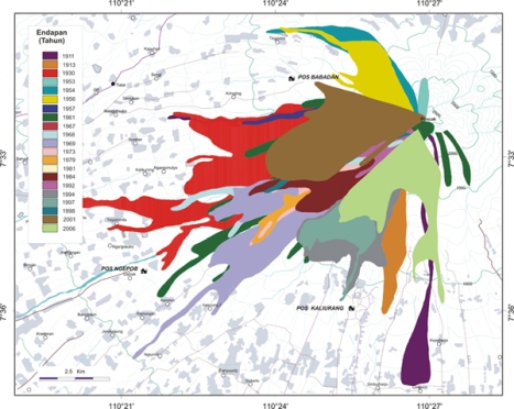
Nearby to the city of Yogyakarta is Mount Merapi. The northern outskirts of the city run up to the southern slopes of the mountain in Sleman Regency (Indonesian language–Kabupaten). Gunung Merapi (literally Mountain of Fire in Indonesian/Javanese), is an active Stratavolcano located on the border between Central Java and Yogyakarta, Indonesia. It is the most active volcano in Indonesia and has erupted regularly since 1548. The volcano last erupted in November 2010.
Administration
The city is divided into 14 districts (kecamatan).
1. Gondokusuman
2. Jetis
3. Tegalrejo
4. Umbulharjo
5. Kotagede
6. Mergangsan
7. Ngampilan
8. Danurejan
9. Kraton
10. Wirobrajan
11. Pakualaman
12. Mantrijeron
13. Gedongtengen
14. Gondomanan
Arts and culture
Yogyakarta is known for its silver work, leather puppets used for shadow plays (wayang kulit), and a unique style of making batik dyed fabric. It is also known for its vivid contemporary art scene. Yogyakarta is also known for its gamelan music, including the unique style Gamelan Yogyakarta, which developed in the courts.
Yogyakarta is also a haven for underground art. It is home to many independent filmmaking communities, independent musicians, performance artists, and visual artists. One underground community that is internationally reputable among art collectors but barely heard of within the country is the Taring Padi community in Bantul, which produces posters using a technique called cukil. daren kidul Dono Kerto Turi
Demography and language
Most population is Javanese, but being a student city, there are also significant population of people from other ethnicities in Indonesia. This status makes Yogyakarta as one of the most heterogeneous city in terms of ethnicity in Indonesia. Indonesian as the official national language, and Javanese are widely used as daily spoken languages, especially by the Javanese.
Education
Yogyakarta is well-known as home of Gadjah Mada University[1],one of Indonesia's most prominent state university. This city also houses several well known private universities such as Muhammadiyah University of Yogyakarta[2], Islamic University of Indonesia[3], Atmajaya University of Yogyakarta[4] and Sanata Dharma University[5]
History
The City of Jogjakarta and the Kingdom of Jogjakarta was established as a result of a "Gianti war treaty" (Perjanjian Gianti) by HRH Prince Mangkubumi, who later become HRH Sultan Hamengkubuwono I. Officially, the creation of Kingdom of Jogjakarta is dated in October 7, 1756 as a result of civil war among the bloodline of The Kingdom of Mataram. The civil war was fought against Hamengkubuwono's and his elder brother, HRH Sunan Pakubuwono II. This civil war marked the end of the Kingdom of Mataram and resulted in the birth of the Kingdom of Jogjakarta and the Kingdom of Surakarta.
The root of the civil war started when Sunan Pakubuwono II agreed to cooperate with the Dutch colonial government and submit to foreign (western) powers. His younger brother, HRH Prince Mangkumbumi (HRH Sultan Hamengkubuwono) stood against the concept, due to concern that his people would become slaves under Dutch rule. The Javanese slaves were used to work for businesses owned by V.O.C. and the Dutch Colonial Government and exported to present day Suriname in South America. In the Netherlands itself, some of the Dutch people stood against the policy of their home government.
Prince Mangkubumi fought until the defeat of the Pakubuwono forces and declared sovereignty in the Kingdom of Jogjakarta south of the original Kingdom of Mataram. Because of this historical act of bravery and sacrifice, Jogjakarta is given Special Administrative Region (SAR) status, making the Province of Jogjakarta the only province headed by a monarchy.
Museums
Due to the importance of Yogyakarta during the war of independence from the Dutch, there are numerous memorials and museums. Yogya Kembali, and Fort Vredeburg are two major museums of about 11 named in the city.
To the east of the town centre is a large air-force museum; as Indonesia was for a period in the Soviet sphere of influence this museum contains a number of vintage Russian aircraft not widely available for inspection in the NATO sphere of influence. The collection includes examples of the Mig 15 trainer (NATO designation Mongol), MiG 17 (Fresco), MiG 19 (Farmer), Mig 21 (Fishbed) and Tu16 (Badger), together with an assortment of American and British aircraft.
Transportation
Yogyakarta is served by Adisucipto International Airport which connects the city with some other major cities in Indonesia, such as Jakarta, Surabaya, Bali, Makassar, Balikpapan, Banjarmasin, and Pontianak. It also connects the city with Singapore (operated by Garuda Indonesia) and Kuala Lumpur (operated by AirAsia and Malaysia Airlines).
The city is located on one of the two major railway lines across Java between Jakarta / Bandung and Surabaya. It has two passenger railway stations, Tugu Railway Station serves business and executive class trains while Lempuyangan Station serves economy class trains. Both stations are located in downtown Yogyakarta city.
The city has an extensive system of public city buses, and is a major destination for inter-city buses to elsewhere on Java or Bali, as well as taxis, andongs, and becaks. Motorbikes are by far the most commonly used personal transportation, but an increasing number of residents own automobiles.
Starting from early 2008, the city has operated a bus rapid transit system called Trans Jogja. This system is modeled after TransJakarta. But unlike Trans Jakarta, there is no particular lane for Trans Jogja buses, they run on main streets. Currently there are six lines of Trans Jogja service, with routes throughout main streets of Yogyakarta, which some overlap one another. The lines extend from Jombor bus station in the north as far as Giwangan main bus terminal in the south and Prambanan bus shelter in the east via Adisucipto International Airport. Trans Jogja has now become a new trademark of Yogyakarta and frequently used by local citizens and tourists alike.
In a recent forum discussion on long-term future transportation plans in Yogyakarta held in Universitas Gadjah Mada, Head of Yogyakarta region transportation master plan team, Prof Ahmad Munawar, said that, in 2016 various modern transport modes include monorail, aerobus, and tram will begin operating in the city and the region.[
Climate
Yogyakarta features a tropical monsoon climate. The city features a lengthy wet season running from October through June and a short dry season that only covers the months of July, August and September. The city averages roughly 2200 mm of precipitation annually. Yogyakarta experiences particularly heavy rainfall from November through April. Temperatures remain relatively constant throughout the course of the year, with average high temperatures at around 30 degrees Celsius and average lows at around 22 degrees Celsius.
In History : Welcome to Yogya
The Yogyakarta Sultanate, formally the Sultanate of Ngayogyakarta Hadiningrat, was formed in 1755 when the existing Sultanate of Mataram was divided by the Dutch East India Company (VOC) in two under the Treaty of Giyanti. This treaty states that the Sultanate of Mataram was to be divided into the Sultanate of Ngayogyakarta Hadiningrat with Yogyakarta as the capital and Mangkubumi who became Sultan Hamengkubuwono I as its Sultan and the Sultanate of Surakarta Hadiningrat with Surakarta as the capital and Pakubuwono III who was the ruler of the Sultanate of Mataram as its Sultan. The Sultan Hamengkubuwono I spent the next 37 years building the new capital, with the Kraton as the centerpiece and the court at Surakarta as the blueprint model. By the time he died in 1792, his territory exceeded Surakarta's.
The ruler Sri Sultan Hamengkubuwono IX (April 12, 1912 - 1988) held a degree from the Dutch Leiden University, and held for a time the largely ceremonial position of Vice-President of Indonesia, in recognition of his status, as well as Minister of Finance and Minister of Defense.
In support of Indonesia declaring independence from the Dutch and Japanese occupation, in September 5, 1945, Sri Sultan Hamengkubuwono IX of Yogya and Sri Paku Alam VIII in Yogya declared their sultanates to be part of the Republic of Indonesia. The declaration is as follows:
"We, Hamengkubuwono IX, Sultan of the Land of Ngayogyakarta Hadiningrat, declared:
* That Land of Ngayogyakarta Hadiningrat function as a monarchy as a Special Territory of the Republic of Indonesia
* That we as the Regional Head of Yogyakarta held control and power in the Land of Ngayogyakarta Hadiningrat, and upon that cause in which the situation nowadays all government elements in the Land of Ngayogyakarta Hadiningrat from this moment is all under our control and with it too all other authorities we take over entirely.
* That the connection between the Land of Ngayogyakarta Hadiningrat and the Central Government of the Republic of Indonesia is direct and we will only bear responsibility upon our Land directly to the President of the Republic of Indonesia.
We ordered that all residents of the Land of Ngayogyakarta Hadiningrat to heed our mandate. Ngayogyakarta Hadiningrat, 28 Puasa, Ehe, 1876" (Javanese Calendar), Gregorian Date: 5 Sept 1945 In return for this support, the declaration of Special Authority over Yogyakarta was then granted fully in 1950.
By this act, Sultan Hamengkubuwono IX was appointed as governor for life. During the Indonesian National Revolution against the Dutch after World War II (1945-1950), the capital of the newly declared Indonesian republic was temporarily moved to Yogyakarta when the Dutch reoccupied Jakarta from January 1946 until August 1950.
The current ruler of Yogyakarta is his son, Sri Sultan Hamengkubuwono X, who holds a law degree from Universitas Gadjah Mada. Upon the elder sultan's death, the position of governor, according to the agreement with Indonesia, was to pass to his heir. However, the central government at that time insisted on an election. In 1998, Sultan Hamengkubuwono X was elected as governor by the provincial house of representatives (DPRD) of Yogyakarta, defying the will of the central government. "I may be a sultan," he has been quoted in Asia Week as saying, "but is it not possible for me to also be a democrat?"
Yogyakarta Special Region Province in History
Yogyakarta is the special province in Indonesia. It is located at southern of Merapi Mount. Yogyakarta divided by Progo River and Opak River in outer range. Lava from Merapi always flows along these rivers. There are five regency / municipality. The regencies are Sleman regency, Kulon Progo regency, Gunung Kidul regency and Bantul regency. The only one municipality is Jogjakarta, that also as capital city of Yogyakarta Special Region Province. Before become a province ot was a part of Vorstenlanden.
History of Yogyakarta Special Region always be related with the kingdom of Mataram. The Kingdom of Mataram was built by Sutawijaya. Sutawijaya was a son of Ki Ageng Pemanahan. He has killed Aryo Penangsang, the enemy of Pajang Kingdom. Pajang Kingdom has given him land that was named Mentaok Forest. Sutawijaya worked hardly to build a kingdom. After he was become a king, he have a tittle Panembahan Senopati. The glorious of Kingdom Mataram was happened when it was handled by Raden Mas Rangsang who was also popular with the tittle Sultan Agung Hanyokrokusumo. The authority was large through over Java island and a part of Sumatera island.
The influence of Mataram authority could be larger again if no VOC here. VOC (Verenigde Oost Indische Compagnie) has occupied many authority region of Mataram Kingdom. Sultan Agung was very angry so he arranged some strategy to attacked VOC. He attacked VOC in Batavia (Jakarta City now), in 1628 and 1629, unfortunately it was failed. VOC burnt food resources of Mataram. Many Mataram soldiers was hungry and no power to attacked in the war with VOC.
After the death of Sultan Agung in 1645, Mataram authority was weaker and weaker, and The Dutch presser was stronger and larger. The Prince of Sultan Agung grandchild were confronted one with another. In the case Dutch always become the third party and got the advantages from the disputes.
Sultan Amangkurat II the grandson of Sultan Agung still could handle his government. Other dispute was occured between Sunan Mas (Sunan Amangkurat III) and Prince Puger. Prince Puger then proclaimed himself to be Sunan Pakubuwono I. At the same time Mataram power faded out since Dutch always tried to divide it by all means.
Sunan Paku Buwono III (the son of Paku Buwono II) was promoted by Dutchto be a Mataram administrator. The instalation made Prince Mangkubumi (The brother of Sunan Paku Buwono II) was disappointed and choosed to back to Ngayogyakarta because of unsatisfied policies of Sunan Pakubuwono and Dutch interference in organizing Mataram. It event again caused a conflict in Mataram. Prince Mangkubumi supported by Raden Mas Said tried to fight against the Dutch (VOC).
Mataram was divided into two region, according Giyanti aggrement on February 1755. Sunan Pakubuwono III ruled the Surakarta Hadiningrat. Prince Mangkubumi reined a new Kingdom, Ngayogyakarta Hadiningrat. Then, Prince Mangkubumi was titled Sultan Hamengku Buwana I. Raden Mas said was finally recognized as the prince who held the power in Mangkunegaran and was called Pangeran Aryo Adipati Mangkunagoro. Until now Mataram broke into two and people in Projo Kejawen (Surakarta and Yogyakarta) suffered more and more. by Irsyadul ibad